Destinations · Chongqing
Chongqing 8D City Guide 2026: 7 Secrets to Survive the Vertical Maze
Your taxi drops you at a busy plaza. You walk to the railing for a photo—and realize you are staring down from the 22nd floor. That is Chongqing: overlapping roads, monorails through apartments, and maps that lie flat while the city stacks in layers.
Chongqing is China’s most visually distinct megacity because elevation is not a single number. Plan for vertical transit, offline-capable maps, and sneakers—not rolling luggage through Yuzhong staircases.
What “8D city” actually means in 2026
The label started as internet slang; locals now use it as shorthand for topography that breaks flat-map logic. 8D does not mean eight physical dimensions—it means you constantly switch between stacked layers: bridge decks, cliffside walkways, metro viaducts, and building podiums that each pretend to be “ground level.”
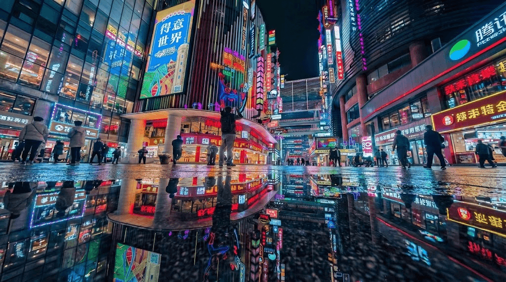
While other Chinese cities spread across plains, Chongqing builds into and through the Yangtze–Jialing confluence. Ridges become neighborhoods; tunnels become retail; WWII air-raid shelters become hotpot halls. The result is less “cyberpunk cosplay” and more infrastructure archaeology you can photograph in an afternoon.
While other metropolises build upward from flat plains, Chongqing builds into, around, and through the mountains. It creates a “vertical city” reality where the subway runs through apartment complexes and GPS navigation frequently fails because it cannot distinguish between the upper road and the lower road overlapping on your screen.
Three reality-bending features you will hit on day one
1. The myth of the ground floor
In most cities, the ground floor is elevation zero. In Chongqing, “first floor” is relative. Buildings on river ridges often have multiple street-level entrances at different heights—each with its own address logic.
Kuixinglou Plaza is the viral test case Chinese travelers cite: you enter a public square that feels like street level, but you are on a bridge connecting two peaks around the 22nd story. There is no illusion—the city simply ignores the idea of a flat plane.
- Map fix: Use Amap (Gaode) in 3D mode; pin your hotel by photo landmark, not street name alone.
- Taxi script: Show the building name in Chinese characters; say which entrance (东门 / 车库入口) when drivers call.
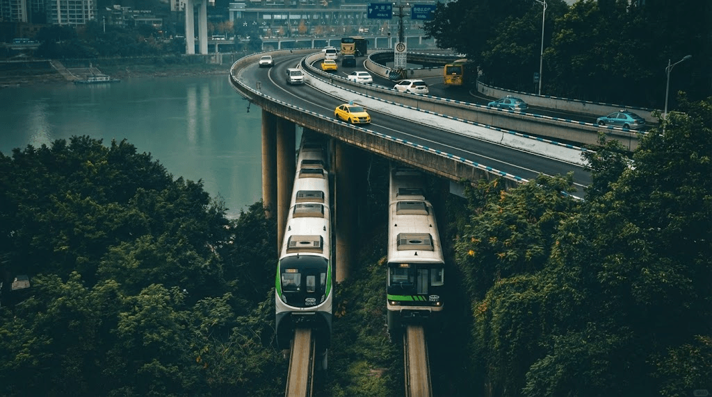
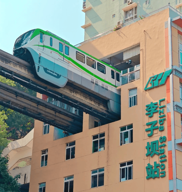
2. Infrastructure that defies zoning
Urban planning here prioritizes making it work over clean separation. The world-famous case is Liziba Station on CRT Line 2, where the monorail passes through a residential tower.
2026 status: Still the city’s most shared clip. The train does not detour around the block—it threads the building. For the driver’s-eye view, board the front car toward Yudong or Jiaochangkou depending on direction, and shoot in late afternoon when the facade is evenly lit.
3. The cyberpunk aesthetic (and why it is real)
The look is not marketing copy—it is historical layering. WWII shelters turned restaurants; “Third Front” industrial heritage; neon retail wedged against 1980s concrete housing. The contrast of the neon-lit Raffles City “horizontal skyscraper” sitting above decaying 1980s concrete housing creates the high-tech, low-life visual signature of the cyberpunk genre.
Spring (March–May) and autumn (October–November) give clearer air for skyline shots. July–August heat tops 40°C; winter fog can erase Raffles City from across the river.
8D photography coordinates: the 2026 hit list
General wandering rarely yields “Inception” frames. Go to coordinates, confirm exit numbers, then walk the last 10–15 minutes with Amap open.
| Spot | Access | Shot notes |
|---|---|---|
| Baiju Si Bridge (“Interstellar” gate) | Line 18, Babin Road Wetland Park, Exit 2; ~14 min walk to riverbank | Hollow teardrop towers; telephoto or 5× phone zoom to compress scale |
| Hongya Cave | Jiefangbei riverside; free entry | 11-story stilt complex; night orange lighting. Skip paid “fast track” scalpers |
| Eling No. 2 Factory | Eling Park ridge | Brutalist industrial courtyards + Yuzhong peninsula views |
| Liziba Station | CRT Line 2 | Train-through-building; platform crowd peaks 17:00–19:00 |
| Qiansimen Bridge | Walk from Jiefangbei core | Hongya + Jialing River; best external viewpoint, not inside the cave mall |
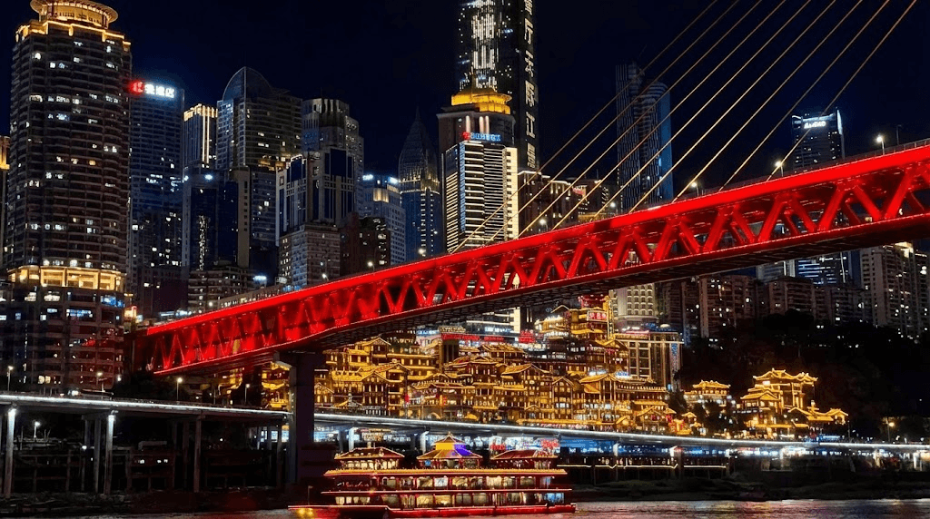
The “Spirited Away” complex: Hongya Cave
An 11-story cliffside stilt village lit warm gold after dark. The interior is a crowded souvenir mall; the iconic frame is from outside. For a guaranteed river angle with less guesswork, browse Trip.com tours & tickets for night cruises that pass the facade.
The urban canyon: Eling No. 2 Factory
Formerly a central bank printing factory, Eling No. 2 is now a cultural hub on a ridge with Yuzhong peninsula views and brutalist industrial courtyards ideal for wide-angle street frames.
Navigating the 8D maze: logistics that actually work
Two-dimensional Google Maps is unreliable on the ground. Build a stack before you land.
Digital survival & connectivity
Google Maps, Instagram, and WhatsApp are not dependable on mainland networks. Regulations and app availability change—verify with your carrier, embassy, and provider before you fly.
Public Wi-Fi often fails foreigners at SMS verification. Load a roaming profile before departure:
- Trip.com China eSIM or Airalo
- Surfshark for hotel Wi-Fi if you split VPN and roaming
- VPN vs eSIM guide
CRT vs. the “Yellow Ferrari” taxis
- CRT (metro): Best value; Line 2 is the sightseeing spine. Buy tickets via station machines or Alipay transit codes.
- Yellow taxis / DiDi: Aggressive, skilled drivers—often the fastest way to jump between vertical layers Google thinks are “500 m apart.”
- Payment: Cash is rare. Set up Alipay in China (2026) and link DiDi inside the wallet.
Walking warning
Do not trust flat “walking distance.” A 500 m pin can mean 30 flights of stairs. Avoid rolling luggage through Yuzhong—hail DiDi between major nodes instead.
The “speed run” itinerary (one intense day)
Adapted from viral city-walk routes (including creator runs through Jiefangbei–Liziba corridors). Order matters less than finishing on the river for night lights.
- Jiefangbei — symbolic center; orient here, not at a random “ground” pin.
- Bayi Road food street — suanlafen (hot-and-sour noodles) before the climb count rises.
- Kuixinglou — feel the 22nd-floor plaza illusion.
- CRT Line 2 → Liziba — front car; short platform stop.
- Crown Escalator — taxi down; Asia’s second-longest urban escalator link.
- Nanbin Road (south bank) — sunset peninsula panorama.
- Night: Hongya Cave. Do not go inside; the view is better from the Qiansimen Bridge.
Essential 2026 travel checklist
- Entry: Chongqing Jiangbei (CKG) participates in multiple transit and visa-free tracks; rules change—see 240-hour transit guide and visa-free country list 2026.
- Footwear: Grippy sneakers; “city walk” here means stair-heavy climbs.
- Stay: Jiefangbei or Guanyinqiao for CRT access; confirm foreign-passport check-in on Trip.com hotels.
- Apps: Alipay (pay + DiDi), Amap (maps), Trip.com (trains/flights).
- Pair trip: Chengdu is ~1.5 h by high-speed rail—combine pandas with the 8D maze on one southwest loop.
Bottom line
Chongqing forces vertical thinking: multiple ground floors, trains through towers, GPS that cannot pick a deck. Book high-speed trains and flights on one partner tab, activate eSIM before you clear immigration, and shoot Hongya from the bridge—not from inside the souvenir levels.
FAQ: Chongqing 8D city 2026
What does “8D city” mean?
Extreme vertical topography—overlapping roads, multi-level plazas, and buildings with several “ground floors”—so flat 2D maps understate real walking and driving routes.
Is English widely spoken?
Less than in Shanghai or Beijing. Keep a translation app offline-capable and save hotel addresses in Chinese.
Can I use Instagram or Google Maps in Chongqing?
Generally not without preparation. Use Amap on a China-ready data plan; configure access before departure.
Best months to visit?
March–May or October–November for weather and photos. Avoid peak summer heat and heavy fog if you need clear skyline shots.
Is Chongqing safe at night?
Yes for street crime; the real risks are uneven steps, wrong-level exits, and dehydration on long stair routes.
Do I need cash?
Rarely. Alipay and WeChat Pay cover metro, taxis, food, and most hotels once your foreign card is linked.
StartChinaTravel earns commissions from some links on this page (Trip.com, Airalo, Surfshark) at no extra cost to you. See How we test and Destinations for related guides.