Chongqing 8D City: 7 Incredible Secrets to Navigating This Mind-Blowing Maze in 2026
Here is the fully revised 2026 guide, updated with your specific requirements regarding compliance, image prompts, Your taxi drops you off at a busy street-level plaza in 2026. You see cars, pedestrians, and shops. You walk to the railing to take a photo, only to realize you are actually staring down a sheer drop from the 22nd floor. This specific vertical disorientation is exactly why Chongqing is called an 8D city—a place where traditional three-dimensional mapping fails to account for the complex layers of infrastructure stacked upon one another.
While other metropolises build upward from flat plains, Chongqing builds into, around, and through the mountains. It creates a “vertical city” reality where the subway runs through apartment complexes and GPS navigation frequently fails because it cannot distinguish between the upper road and the lower road overlapping on your screen.
The Logic Behind the “8D” Label
The term “8D” started as internet slang but has become the accurate definition of the city’s topography. Here is the breakdown of the three reality-bending features you will encounter.
1. The Myth of the Ground Floor
In most cities, the ground floor is elevation zero. In Chongqing, the concept of a “first floor” is relative. Because the city sits on ridges formed by the Yangtze and Jialing rivers, buildings often have multiple “ground” entrances at different elevations.
The Prime Example: Kuixinglou Plaza
Local Chinese travelers frequently cite Kuixinglou as the ultimate 8D test. You enter a public square that feels like street level, but it is actually a bridge connecting two peaks at the 22nd story. There is no magic trick; the infrastructure simply ignores the concept of a flat plane.
2. Infrastructure That Defies Zoning
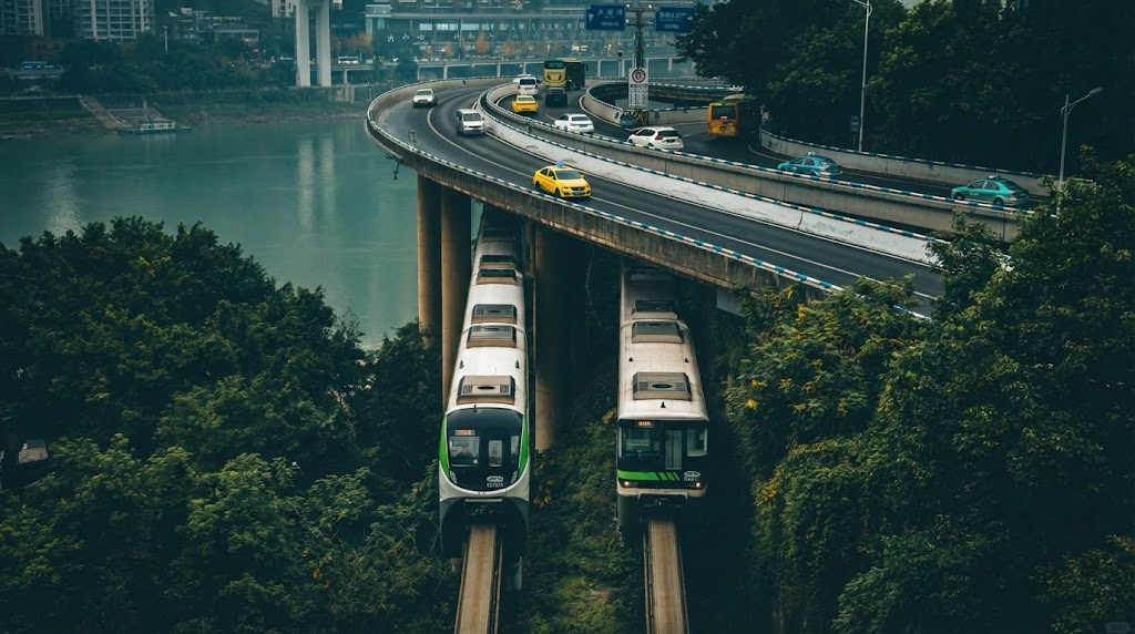
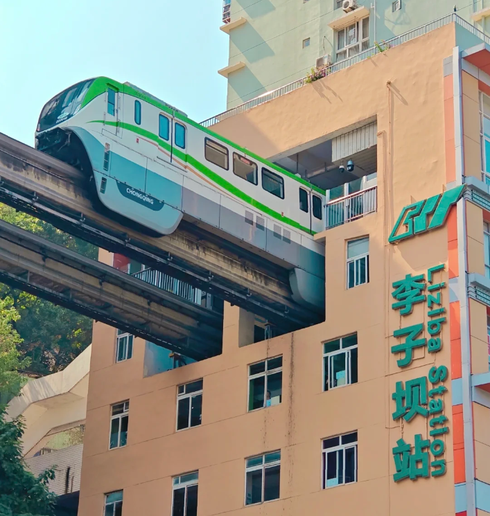
Urban planning here prioritizes “making it work” over separation. This results in the world-famous Liziba Station, where the CRT (Chongqing Rail Transit) Line 2 passes directly through a residential apartment building.
- 2026 Status: This remains the city’s most viral visual. The train does not go around the house; it goes through it.
3. The Cyberpunk Aesthetic
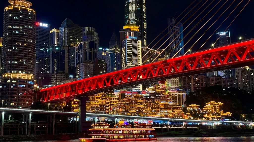
The “Cyberpunk” label is not just marketing; it is a result of historical layering. From WWII air raid shelters (now converted into hotpot restaurants) to the “Three Fronts Construction” era of heavy industry, the city has always dug deep and piled high. The contrast of the neon-lit Raffles City “horizontal skyscraper” sitting above decaying 1980s concrete housing creates the high-tech, low-life visual signature of the cyberpunk genre.
8D Photography Coordinates: The 2026 Hit List
To capture the “Inception” style shots, you must go to specific coordinates. General wandering will not yield these results.
The “Interstellar” Gate: Baiju Si Bridge
- Location: Line 18, Babin Road Wetland Park Station, Exit 2.
- The Shot: The bridge towers are designed as massive, hollow teardrops. Viewed from the riverbank below (a 14-minute walk from the station), they look like a sci-fi portal.
- Pro Tip: Use a telephoto lens or 5x zoom on your phone to compress the background, making the bridge loom massively over a human subject.
The “Spirited Away” Complex: Hongya Cave
- Location: Jiefangbei / Riverside.
- The Reality: An 11-story stilt house complex built against a cliff. At night, the warm orange lighting mimics the bathhouse in Miyazaki’s Spirited Away.
- 2026 Warning: Do not pay for “fast track” entry or “VIP elevators.” Hongya Cave is free. Scalpers target tourists at the top entrance.
- Action: Book Hongya Cave Night Tour on Trip.com (Only if you want a guaranteed boat view).
The Urban Canyon: Eling No. 2 Factory
- Location: Eling Park area.
- The Vibe: Formerly a central bank printing factory, now a cultural hub. It sits high on a ridge, offering views of the Yuzhong peninsula while surrounded by brutalist industrial architecture.
Navigating the 8D Maze: A 2026 Logistics Guide
You cannot rely on 2D maps here. Follow these survival protocols to avoid getting lost in a cul-de-sac 15 floors up.
1. Digital Survival & Connectivity
Many international websites and apps (Google Maps, Instagram, WhatsApp) are not accessible in mainland China. Travelers usually prepare access solutions in advance before departure.
Important Notice
Regulations regarding internet access, mobile connectivity, and app availability may change. Always check the latest official guidance from airlines, embassies, and service providers before travel.
- Connectivity: Public Wi-Fi is unreliable for foreigners due to SMS verification barriers. We recommend securing a digital SIM before you fly.
- Action: Get China eSIM
2. Transport: The “Yellow Ferrari” vs. CRT
- The Metro (CRT): Reliable and bypasses traffic. Line 2 is the sightseeing line.
- Taxis: Local yellow taxis are nicknamed “Yellow Ferraris.” The drivers are aggressive and skilled. In practice, they are often the only way to move between “levels” of the city quickly.
- Payment: Cash is rarely accepted. You need Alipay.
- Read Guide: How to Use Alipay in China (2026)
3. Walking Warning
Do not trust “walking distance” estimates. A “500-meter walk” on a map might involve climbing 30 flights of stairs.
- Mistake to Avoid: Dragging rolling luggage through the Yuzhong district. The stairs will destroy your wheels. Hail a taxi via the DiDi app (inside Alipay).
The “Speed Run” Itinerary (Insider Route)
For a high-intensity single day that covers the verticality, follow this route adapted from recent viral live streams (like IShowSpeed’s route):
- Start: Jiefangbei (The symbolic center).
- Eat: Walk to Bayi Food Street for hot and sour noodles.
- Shock: Walk to Kuixinglou to experience the “22nd-floor ground level.”
- Ride: Take Line 2 to Liziba (Train through building). Try to get the first car for the driver’s view.
- Descent: Taxi to Crown Escalator (Asia’s second longest escalator).
- Sunset: South Bank (Nanbin Road) for the view back toward the peninsula.
- Night: Hongya Cave. Do not go inside; the view is better from the Qiansimen Bridge.
Need to book your transit to Chongqing?

Essential 2026 Travel Checklist
Before you arrive in the Mountain City, ensure you have ticked these boxes:
- Visa/Entry: Chongqing Jiangbei International Airport participates in China’s transit without visa programs. Eligibility, permitted duration, and entry ports may change. Always verify current rules with official sources before departure.
- Footwear: Bring your most comfortable sneakers. “City Walk” here means “City Climb.”
- Accommodation: Stay in Jiefangbei or Guanyinqiao for easy metro access.
- Action: Find Hotels on Trip.com
- Apps: Alipay (Payment), Amap (Maps – use visual interface if you can’t read Chinese), Trip.com (Bookings).
FAQ: Chongqing Travel 2026
-
What does “8D city” actually mean in Chongqing?
It describes the city’s extreme vertical topography, where overlapping roads, multi-level plazas, and buildings with several “ground floors” make conventional 2D maps insufficient for navigation.
-
Is English widely spoken in Chongqing?
No. English proficiency is lower here than in Shanghai. You must have a translation app ready on your phone.
-
Can I access my usual social media apps in Chongqing?
Generally, no. Foreign platforms like Instagram and Google are not accessible. Travelers usually configure their devices before arrival to ensure connectivity.
-
What is the best time to visit?
Spring (March-May) or Autumn (October-November). Avoid July/August (extreme heat 40°C+) and heavy fog seasons if you want clear photos.
-
Is it safe to walk at night?
Yes, Chongqing is very safe. The biggest risk is tripping on uneven stone steps or getting lost in the complex walkways.
Conclusion
Chongqing is not just a city; it is a physical challenge to your sense of direction. It is called an 8D city because it forces you to think vertically. For the traveler in 2026, it represents the most visually distinct urban experience in China—chaotic, loud, and completely unique.
Next Step: Secure your connection before you fly. Get China eSIM to ensure you don’t get lost in the vertical maze.